Sunday, July 22, 2012

Gettysburg's Little Monuments

What You Can Learn from Position Markers

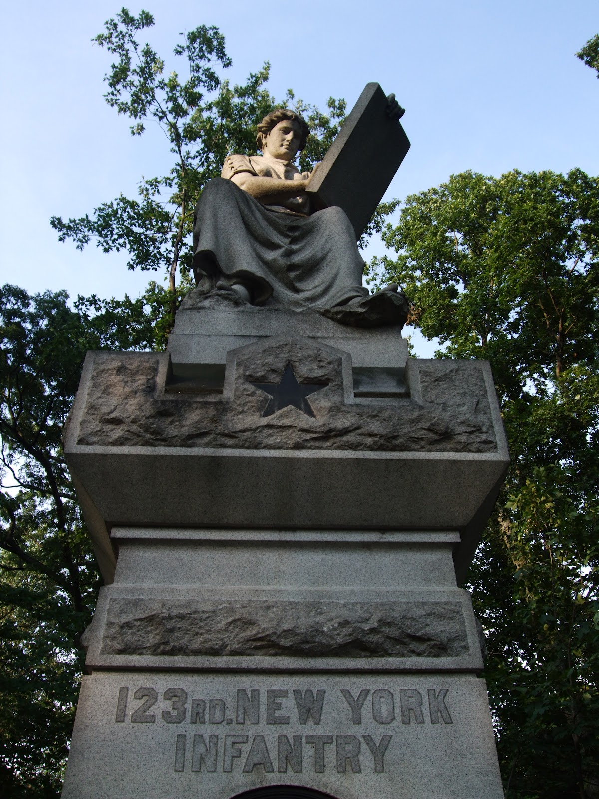
Gettysburg visitors and locals are familiar with the detailed, moving monuments to all the troops that served. These monuments are often located near or at the position of a particular groups at Gettysburg. The monuments of the battlefield tell the story, often listing the number engaged, and the numbers killed, wounded, and missing. Some will also list the other battles in which a brigade or battery participated. The most detailed will include the place and date in which the soldiers were mustered in and out. You may be surprised to discover where and when the soldiers were officially no longer serving, since some of the men were mustered out far from home at the end of the Civil War. You can watch the cars drive by and slow down to read the monuments. Even the children and teens in the party are often intrigued by the emotion and art that pair with stone to create a lasting reminder for us of the sacrifices and the bravery of those who fought. This monument to the 123rd New York Infantry exemplifies that blend of emotion and art. Lit by the rays of the setting sun Clio, the Muse of history is writing down the record of the 123rd's service. On the monument, the star indicates that this troop belonged to the Twelfth Corps. All the Twelfth Corps monuments feature a star in some place. on the monument.
These monuments, often majestic and intriguing, will make people stop or slow down. However, less imposing, smaller, markers can also tell the story. Battlefield visitors walk right by these because they do not usually feature designs and often have just a few cryptic letters. To really learn about the battlefield requires a visitor to slow down -- and look down. The details of the battle story are right there in the position markers. Position markers are full of information, once you know how to decipher the few letters inscribed on them. Many are hard to read and require you to get down next to them, but doing so will help you to really see how the troops were placed. Usually placed at the same time as the larger monuments, the position markers can tell the location of the flanks -- or sides. These flank markers tell how far the line extended on either side. You can identify the right flank and the left flank by reading the monument. Thus R. F. means right flank and L.F. means left flank. Occasionally, the position markers will include dates. These markers were placed in most cases when veterans of the battle were still alive to describe the location, and they are so valuable because they tell us much about the soldiers. This is a position marker for the 123rd NY Infantry.

On this position marker, you can identify that they belonged to the Twelfth Corps by the star. This marker also includes the dates July 2 & 3 1863, and stipulates that this was the left flank. You can stand at a position marker and figure out which way the soldiers were moving, or where there attackers were located. This is a very complete marker; some are more abbreviated or harder to decipher.


This marker, also on Culp's Hill, identifies the left flank of the 1st Maryland, of Steuart's Brigade of the CSA. Their monument is nearby this location on lower Culp's Hill.


Many markers are harder to decipher. Can you tell what the position marker on the right indicates?


This marker, also on Culp's Hill delineates the left flank of the 29th Pennsylvania Volunteers. There is a larger monument nearby that describes the service of the 485 men who comprised the 29th.


The placement of position markers can also tell which troops fought side by side. In this picture, one sees the right flank of  the 5th Ohio Volunteer Infantry and the left flank of the 147th Regiment Pennsylvania Volunteers. On the position marker of the Ohio men, you can also see the star of the Twelfth Corps.


The story of the 66th Ohio Volunteer Infantry is told at the top of Culp's Hill. There you will find their monument on the east side of the hill. Close by is the position marker identifying the right flank.
The rest of the story is told several hundred yards down a steep path on the heavily forested east side of the hill. Here perched atop a boulder is the left flank monument. Finding it is well worth the walk down the steep hill because standing on the boulder and looking out toward the east, and down toward where the Confederate troops were gives you a sense of place, a sense of the wooded battlefield in which these men fought. I walked down on one of those humid 90 plus degree days of mid-July and found just walking to be difficult. The Ohio position markers, however, are not placed in the same manner as others. You can discover the arduous process of ordering and placing the monuments by reading the entries here:
 http://www.gettysburgdaily.com/?p=13072


 The next time you are walking through the winding roads of the battlefield, take a look down and find the position markers. Once you can decipher them, you will discover much more about the men who fought here.


Wednesday, July 18, 2012

Pardee Field on Culp's Hill

"This they did in handsome style"

Locals are likely to walk in the area of Devil's Den, and to know more about the battle for the Round Tops. Getting to know Culp's Hill is an adventure since this area has undergone recent changes during the NPS clearing of trees. A drive along Geary Avenue proceeding away from Spangler's Spring leads one past an open meadow in which several paths have been mowed. This road slowly climbs to the lower part of Culp's Hill. The avenue winds through what was one large field in 1863. Nearly in the center of that meadow, surrounded by grass and wildflowers stands a single boulder, placed in 1905 by the Commonwealth of Pennsylvania, and inscribed in 1906 with two words: Pardee Field. This area, named for the commander of the 147th,  has been cleared of trees and restored to the meadow that was once there. It is actually located between Slocum Avenue above, and Geary Avenue below. As you drive along the battlefield, you note that most of the monuments are granite or limestone, and range in color from ivory to gray. The boulder in Pardee Field however, appears almost golden in the sunlight. It was brought to this site from elsewhere and has been described variously as sandstone or granite. On the left side of the monument is a bronze plaque which tells the tale of how this five acre meadow was the path for the Pennsylvania 147th Infantry to regain ground that had been briefly held by Steuart's Brigade, CSA.
At 5 a.m. the one hundred and forty-
seventh Penna. Volunteers (Lt. Col. Ario Pardee Jr.)
was ordered to charge and carry the stone
wall occupied by the enemy. This they did in
handsome style, their firing causing heavy
loss to the enemy who then abandoned
the entire line of the stone wall.
Report of Brig. General John W. Geary,
commanding 2d Division 12th Corps

At 5 a.m. on July 3,  troops from the Army of the Potomac, including the 147th and the Seventh and Fifth Volunteer regiments from Ohio did advance here and retake the area that had been briefly held by the First Maryland CSA of Steuart's Brigade. Accounts differ and tell a tale of the importance of skirmishers in engaging the enemy. Pardee himself wrote following the battle:
"On the morning of the 3d, we marched to a point near the line of the previous day and toward the right of the line of the brigade, having on our right the Seventh Regiment Ohio Volunteers and on our left the Fifth Regiment Ohio Volunteers. Soon after the line was formed, I was ordered by General Geary, commanding division, to move forward with my regiment to a point which commanded the right of the line of entrenchments, and from which a view could be had of the movements of the enemy. My regiment, soon after reaching its assigned position, became engaged with the skirmishers of the enemy, who were soon driven from their position. Skirmishers were sent to the front and right flank, into the woods, from which they greatly harassed the enemy. At about 8 a.m. an attempt was made by the enemy to turn the right of the line of the entrenchments. They boldly advanced to within about 100 yards without discovering my regiment. I then ordered the regiment to fire, and broke their line. They reformed again as a body and advanced. Their advance was checked by the heavy fire they received, when they broke and ran."

 On the other side of Geary Avenue lies this monument to the 147th erected by the Commonwealth of Pennsylvania in 1885, which states:  On the night of July 1st this regiment lay on the northern slope of Little Round Top holding the extreme left of the Union Army. At 6 a m July 2d moved to Culp's Hill where it was held in reserve until evening, then marched toward the left with the Brigade. Returning at about 3 a m July 3d and occupied this position. Of the 12 officers and 286 men present at Gettysburg, one officer and five men were killed and 14 men were wounded.On the day that I took this picture, the sun in the west added a second star to the monument.
The story of what happened in the meadow that has come to be known as Pardee Field is the story of the bravery and fortitude of men who were ordered to advance and take ground, and accomplished that goal. It is a story with two sides, because on the other side of that stone wall lies a marker which shows the farthest advance of the 1st Maryland CSA, and their story will be the another post. 
Getting to Pardee Field is an easy walk from Spangler's Spring along Geary Avenue. As you walk, note the monuments to the Fifth Ohio and 147th Pennsylvania, then walk up the incline to the Pardee Field monument, retracing the movements of those troops on July 3, 1863. 

As you walk through the meadow, watch for dragonflies and butterflies. This picture captured an insect on a milkweed plant. In Pardee Field, naturalists have identified the presence of the hoary frostweed, a species identified as endangered in Pennsylvania. I have not yet seen the plant, which has yellow flowers.
http://www.nps.gov/nero/science/FINAL/GETT-EISE_T%2BEplants/hoary_frostweed2.pdf
Bring a camera because the meadow and monuments will be perfect photo opportunities.
After you leave the monument, continue on a path upward to the stone wall that the men were ordered to take. Just on the other side of that wall is a small positional marker indicating the farthest point occupied by the First Maryland, CSA of Steuart's Brigade. You can continue back along Slocum Avenue to the parking lot at Spangler's Spring,

Monday, July 16, 2012

Reid's Orchard Winery

Beautiful Drive, Wonderful Wine


Reid's Orchard Winery is well worth the trip to the beautiful Buchanan Valley. The tasting room is located just off Buchanan Valley Road, surrounded by orchards. The orchard hosts free concerts, often featuring local artists throughout the summer. Go for the apple cherry wine, which is a perfect blend of summer sweetness and autumn tang. Like other local wineries, Reid's also has an "in-town" site, at Jennie Wade's birthplace, 242 Baltimore Street in Gettysburg.

Local Fruit, Local Grapes

 As you approach the tasting room, notice the grape vine laden with grapes. If you have brought the family, this is an excellent place to talk about how grapes grow. When I was there in early July, there were bunches still green. Local, local, local! Reid's grows its own fruit and grapes or purchases excess from other local growers. This means the fruit does not have to be trucked for long distances and can be used at the peak of sweetness, In Adams County, surrounded by orchards, the fruit wines seem especially appropriate. Fruit wines abound at Reid's, and range in sweetness and flavor. The strawberry wine is not cloyingly sweet like some that are sold; it is more complex and interesting. Apple cherry was my favorite choice, and has been been a family favorite. Other fruit wines include apple & blueberry. 
The wine that whispers summer and promises evenings under the stars is Volunteer. I would drive twice as far to get it! This wine is a fortuitous meeting of Catawba, Concord, and Cayuga grapes. Red wines include a popular Merlot, Seminary Ridge Red, Richmond Rebel, Angels of the Battlefield Cabernet Sauvignon, a Pinot Noir, and Troika. I am definitely going back for Muskets of Maine Moscato, one of the whites and a Chardonnay (there are three Chardonnay choices available). Other white wines include Pinot Grigio and Sharpshooter Cayuga.

As you can see, the labels refer to Gettysburg or Civil War subjects in most cases, and thus the wines will be excellent mementos of a visit to Gettysburg -- or for locals, a reminder of how lucky we are.

A Word about Prices for Local Wines

Local wines, like micro-brewery beer are not mass produced. Thus, the prices are in line with mid-price wines, not the cut rate prices. But paying for local products is well worth the money. Often, the wines are created from local fruits and grapes as is the case with Reid's and other local wineries. Supporting local businesses is a pleasure, especially when they offer wines that far surpass the mass produced ones at the liquor store.  And for all the Gettysburg locals, start planning weekend afternoons at Reid's.


 http://www.reidsorchardwinery.com/

 http://www.gettysburgwineandfruittrail.com/


Saturday, July 14, 2012

Troop Movement

Driving in Gettysburg


 Aren't you glad you're not trying to get around on this road? In 1863, the major roads of Gettysburg were already in existence. Roads were dry and dusty or wet muddy troughs, with ridges and tracks, but they allowed movement from one area to another with some efficiency.  This picture, from the work of famous photographer Matthew Brady shows a view of Gettysburg with  both bystanders and soldiers. Soldiers marched at varying rates, but could cover from 8 to 20 miles in a day. Troop movement at Gettysburg was facilitated by the existing roads, which led to cities in both Maryland and Pennsylvania..  Today, traffic in Gettysburg flows smoothly for the most part. At times though, locals and visitors feel that the movement on some roads has slowed to 1863 rates. Add an increased number of cars to the many pedestrian crossings plus drivers looking for available niches for on-street parallel parking, and the result is at times frustration. Today's post will look at parking, pedestrians and preferred passages -- otherwise known as shortcuts.

PARKING

On-street metered parking  is available in Gettysburg along the major roads, at the Racehorse Alley Parking Garage, and at several public parking lots. I have always thought that hotels should remind patrons to bring along a roll of quarters when they travel. The rates for each meter are posted on the meter, and rates do vary, as do time limits. Many meters have a two hour time limit, so be sure to read your meter before you load it up with quarters. Pull in parking is available at the "Square" -- the intersection of York Street, Chambersburg Road, Carlisle Pike, and Baltimore Street. This is a traffic circle, and traffic in the circle always has the right of way. There is plenty of room to back out of these spaces,but you'll need to wait your turn to join the flow of traffic. Other spaces on roads are parallel parking. Please remember that BLUE parking meters are for handicapped citizens who have either a handicapped pass hanging from a mirror or a handicapped license plate.  This is really important, and worth remembering. Moreover, you will receive a ticket and a fifty dollar fine if you park in front of one and are not handicapped. Also, some hotels will have covers over the meters in front of them because they are reserved for hotel guests who are checking in.   http://gettysburg-pa.gov/parking.htm

PEDESTRIANS 

Look out! Someone is jaywalking. That someone may be you someday, so be aware that people strolling around shopping may just decide to cross at random places, emerging from behind those cars parked along the streets. Even more importantly, at the square, there are no traffic lights, and traffic MUST stop for   pedestrians in a crosswalk. It only takes a minute, and the system works relatively well if everyone follows the rule. As you enter the square, note the "Yield to pedestrians in crosswalk" sign. That means you.Also, when you see a crosswalk and the yellow pedestrian sign on Baltimore Street just past Farnsworth House, you must stop. On Steinwehr Avenue, there is also a mandatory stop crosswalk at Dobbin House.

PREFERRED PASSAGES  -- SHORTCUTS AND EASY WAYS


. Most roads on this map are still important in getting around in Adams County. Missing from this map is the current Route 15, which intersects with York Road (Route 30), Hanover Road (Route 116), the Baltimore Pike, Taneytown Road (Route 134), and Steinwehr Avenue (the Emmitsburg Road in 1863). York Road, Route 30 east can be maddeningly slow, especially on Friday afternoons for some reason. There are several traffic lights, but the slowdown seems inexplicable. If you are already on York Road, headed east when traffic slows to a crawl...or worse, take a slight heft turn onto Hunterstown Road. On the map above, this road is unmarked, but travels diagonally off York Rd. across the railroad tracks. You'll drive about a mile, then turn right at the 4 way stop onto Shealer Road.

This road will take you to Wal-Mart and to a traffic light at York Road. Locals use this road often, but it is still not very traveled. If you are in town, say at the square and want to go to Gateway Gettysburg or to Ruby Tuesday, Hoss's or other stores east of town, then follow Business 15 North, Carlisle Street to East Lincoln Avenue to Old Harrisburg Road and turn right onto Shealer Road. This might not be actually shorter, but I am a fan of keeping moving rather than simply stopping. 


Friday, July 13, 2012

The Best Times to See the Sites

Looking for the Road Less Traveled

Summer in Gettysburg means crowds. Locals know that and we're resigned to taking a little more time in the square. We actually like all the crowds and families, and local businesses thrive. In town and along the roads of the battlefield finding a parking spot can be a challenge. On the avenues of the battlefield it is possible to slow down and look at the monuments, but not to really read the inscriptions. So, one must pull over at one of the pull in sites or find a parking spot. Anyone who has tried to park at Little Round Top in the afternoon from May to September knows that can be a challenge at some times and in some places. Today's post is all about the evening, and the alluring stillness that you can find from 7 to 8:30 p.m. The photograph above depicts a moving monument to the Indiana troops who stormed across the meadow toward Spangler's Spring and Rock Creek. This attack is described in the Park Service's sign "Slaughter at Spangler's Spring" which is near the parking lot at Colegrove Road. This picture was taken about 7:15 pm on July 12. I was parked at the parking lot at the spring, and there was only one other car.
I had time to really read the inscription, and was moved looking at the word "EQUALITY" above the description of the action. I hoped they knew, these men from Indiana who had traveled so far to defend the Union how far we have come on the path to equality. Their sacrifices were not in vain. From the monument, I meandered along the road to the loop formed by Colegrove and Carman Avenues. Thrushes called from the forest, and two cardinals flew across the road and back again. I was utterly alone, except for a single truck that drove by.  This loop could also be a way to get from the Culp's Hill & Spangler's Spring area to the Baltimore Pike. There were monuments to New Jersey as well as Indiana and Massachusetts. I had time to consider the clearing of the trees between the spring and the Baltimore Pike. I had been uneasy with the clearing of so many trees and the destruction of habitat, but now I could see that "I am the earth; let me work" is true. The damp meadow actually is habitat for many creatures and plants that have moved in to heal the scars left behind in the clearing. Southern agrimony, a native plant, blooms along the edge of the road. In the small rill that runs under the road are some very fast crayfish, if you have the time to look. And, with no crowd around, you don't have to feel silly looking at the crayfish and frogs, even if you haven't brought along children or grandchildren. At 7:30, ghost walks have not yet begun in town (during summer), and you have probably finished supper, so this is the perfect time to find your places on the battlefield. If you are in the Culp's Hill area and drive along Geary Avenue, look west. You will be rewarded with sunset lighting the sky pink. Sunset over Cemetery Hill is a magnificent picture opportunity. Just as rewarding, if you would like to see the forest in the area without their monuments, is a short ride along Williams Avenue. As you reach the statue of John White Geary, go straight onto Williams Avenue, which looks as though it merely parallels Geary and goes around the back of the monument. Actually, it is a narrow seldom driven road on which you can see the fence that separates the National Military Park from private land. At first, I thought that I was on a forbidden path because it seems so different from Geary Avenue.At a stop sign, turn left to proceed to Stevens Knoll. Here you will find more picture opportunities at sunset.

Round Top

But what about the more popular spots? Evening is actually the optimal time to visit or revisit Little Round Top as well. Parking is much easier, and while you probably will encounter others, there are no crowds. Here is the monument to Major Gouverneur Warren, Chief of Engineers of the Army of the Potomac. Visiting after 7 pm and before darkness afforded us the opportunity to pause and ponder this view, looking out over what has come to be known as the Valley of Death, and beyond. Warren is said to have stood on this very boulder surveying the field of battle. If you have children along, the more comfortable evening time can be a perfect opportunity to ask and answer questions. Also, the very popular monument to the 44th New York Infantry, which children often call "the castle" is less crowded so you can linger. Climbing the spiral staircase is well worth the effort because the observation deck is roomy enough for several at once, and an ideal vantage point to look out over the battle venues to the west. Sunset views from the castle, looking west could provide excellent pictures, and even better memories.

If you go: 
Remember that in summer, the park closes at 10 pm, so plan accordingly. By 8:30, dusk makes everything gray down in the valleys, but higher ground will still be light. Leave your windows open to hear the haunting calls of thrushes and other birds. There is a very noisy pileated woodpecker in the area of Spangler's Spring.
You can access the Spangler's Spring and Culp's Hill sites from East Middle Street, at the intersection with Liberty. The parking area for Little Round Top is on Sykes Avenue.


For further information:


http://www.gettysburg.stonesentinels.com/index.php


Wednesday, July 11, 2012

East Cavalry Field Discoveries

Looking & Learning Locally


Incongruities, small graces, moments of connection and simple beauty -- time spent at various venues of Gettysburg National Military Park can yield all of these. I used to be an impatient one, driving through and noting the "important" places, then driving on. Living in Adams County affords me the opportunity to do so much more than that now. Today's post is all about observation, taking the time to see beyond those quick glances and observe all that is there. One day, near sunset on East Cavalry Field, I was watching a doe graze impassively despite the occasional car that passed by. I was near the turn where Cavalry Field Drive leaves the national park along Confederate Cavalry Avenue. Here there are examples of the artillery from the battle, aimed across an open field. From the road, it appeared that the cannon was aiming across the meadow at the deer. I was struck by the juxtaposition of the serenity of the field and tree line, the grazing deer, and the weapon of death.


As I drive along the roads, the monuments sometimes seem to have become part of the scenery, and I hardly notice them, but this year I have started to pause and look, to walk the same ground that the troops here honored walked 149 years ago. For many, the fighting of July 1 is merely a prelude to the battle, but the action in the railroad cut was dramatic and in many ways played a vital role in events to come. Accessed from the Chambersburg Road west of Gettysburg, the monuments on Reynolds Avenue tell the tale of those units that were involved. This monument to the 147th New York Infantry, which is on the spot of their position in the morning on July 1, 1863,  was erected in 1888. It tells the story of the soldier's life in this beautifully crafted detail. Cast in bronze, this part of the monument can be found just above the seal of New York state. Attached to the knapsack with straps of bronze is a bedroll, a canteen, and a cartridge box -- a soldier's "home" and battle equipment all compactly linked. Inscribed on the pack, the word Oswego is the name of the county in New York from which these soldiers came. The strap of the canteen, and the straps attaching the bedroll to the knapsack actually seem to drape naturally, as though they were still made of leather and not metal.

But to see this detail, one must look closely because a quick glance is not enough. The monument to the 147th New York Infantry stands near the 3rd Indiana Cavalry monument, seen here in the background. 

Surprise Inside


 Napoleons and 3 inch rifles are frequently called cannons by those (like me) who are not experts. On Confederate Cavalry Lane these are pointed across the field. This battalion was engaged in the battle at East Cavalry Field on July 3, 1863. The 3 inch rifle was one of the most common used during the war, and fired shells that weighed eight or nine pounds. Slightly larger, the Napoleon fired twelve pound shells. If you have ever heard artillery fire at a reenactment, you can imagine the noise that the five described here could create. On the battlefield, round wooden disks plug up the cannons, and I was interested in a reason for that. I thought that perhaps vandals stuffed debris or trash inside. Yesterday, July 10, I was walking along peering into the cannons and comparing the round disks inside. But then, there was one that had lost its disk or never had one. Tucked away about 18 inches down the barrel of the cannon was a cluster of dried grass,
 

  and on the grass....

 3 blue eggs.

I have seen bluebirds perched on these cannons, so I think that these are bluebird eggs, nestled deep in the barrel of a cannon. I hope that they are safe. I hope that others who observe and wonder will also be content to walk away.


Tuesday, July 10, 2012

Wine ( and Night Life) at the Top of the Hill

Hauser Estate Winery

Drive west for wine! From Gettysburg, that could be your mantra. Of course, you could stop for tasting and wine purchases on Lincoln Square in downtown Gettysburg. But the drive west along route 30 (the Chambersburg Road) can prove rewarding. The crunch of gravel heralds the drive along the sloping hillside that is the home of Hauser Estate Winery; here there is a tasting room and so much more. The view from the top is lovely in every direction and in every season. Come for a tasting and linger in the bistro chairs outdoors.

People Should Taste in Glass Houses

Everything about the house at the top of the hill appeals to me. I love the rich chestnut color of the wood, the stone walls and arches, and especially -- the glass. All the glass. All around the house, 360 degrees of view. The building seems just right for its perch in orchard country. Tables line two sides on stone and wood verandas.  You can also purchase cheese and snacks and have a glass of wine or hard cider on the veranda. From here, you can savor the beauty of Adams County and try to figure out just what you are seeing from every vantage point.
 Tastings are held at the counter which allows patrons to look out along the sides. You can select which wines you would like to sample. Tastings cost $2.00 and do not include the reserve wines. Sampling Devils Den also brings an accompanying chocolate. Reserves can be tasted for a separate charge. However, there are wines for every taste. Wines from Hauser also give a nod to Adams County and Civil War history and thus could make appropriate gifts for returning home. 


Reds
Devils Den          Pinot Noir         Chambourcin
Whites
Jennie Wade       Pinot Gris           Reserve Chardonnay
Fruits
Apple Wine  
Listed as Rose
The Sweet One (I love this...and the name makes it a great gift choice)  

  "Produced from Pennsylvania Apples. Pressed Onsite. Never From Concentrate. Cheers."

These words from the Jack's Hard Cider website sum up what is unique about the hard cider at the Hauser Estate. For those looking for a taste of European style hard cider, Jack's offers a USA product that fits the bill.  If you're not a wine drinker, then by all means go to the estate and get a glass of cider to sip while on the veranda. My family has sampled most of the varieties, and we all have different choices. Rome is my favorite, with an effervescent sweet/tart and decidedly refreshing taste.Others like the traditional or Helen's. Originally sold in bottles, the cider is now available in cans.

http://jackshardcider.com/

When Night Comes...

Hauser After Hours, Sips and Sounds, Thirsty Thursday... choices for night life at the top of the hill could meet many tastes. there is even catering by the A-ville Inn available. You might find everything from blues to Shakespeare. Locals and tourists alike converge for night activities. Check the website for the latest information.


http://www.hauserestate.com/events