Tuesday, July 31, 2012

Menchey's Spring

At the foot of East Cemetery Hill

       One of the overlooked but important places at Gettysburg National Military Park is Wainwright Avenue, named for Charles Wainwright, commander of the 1st Corps Artillery, who was instrumental in the Union defense of East Cemetery Hill. If you have the time, walk down the hill  from the crest of East Cemetery Hill and walk along Wainwright Avenue. This is a road, so you'll have to watch out for the occasional car. Along this road stand  monuments to the soldiers who defended this hill when Jubal Early's troops attacked from the northeast on July 2, 1863. Here, regiments from New York, Massachusetts and Ohio confronted their attackers. The Union troops were driven back and the Confederates took over the hill for a time, but Union reinforcements arrived in time to regain the hill. General Winfield Scott Hancock, whose statue is on the crest of the hill, sent Carroll's Brigade from Cemetery Ridge to the embattled Union position.
The monument to the 41st NY Infantry and the position markers for the 68th and 54th NY Infantry stand at the bottom of the hill indicating the positions of these regiments. Just across Wainwright Avenue, which was called Brickyard Lane, and at times Winebrenner Lane, is a spring which is still bubbling with water. This spring, Menchey's Spring, provided cool refreshment to the embattled Union troops, but was also the site at which Confederate sharpshooters picked off members of the 54th NY Infantry. Lined by fences, the spring still offers a place to pause, look out across the field to Culp's Hill and remember the troops who fought here. As late as 1915, the remains of a Union soldier were found near Menchey's Spring. With only the USA buckle, buttons, and a "cap box" as identifying characteristics, it was assumed that the soldier might be a member of the 41st NY; he was buried at the National Cemetery.


Friday, July 27, 2012

Steuart's Brigade

First Maryland C.S.A.

     One of the few regimental monuments of Confederate troops is located on Culp's Hill. This marker to the 2nd Maryland Infantry C.S.A. is located on lower Culp's Hill. It is actually a monument to the regiment known during the battle as the 1st Maryland Infantry C.S.A., but in order to avoid confusion with Union forces known as the 1st Maryland, this monument has "2nd" and is also inscribed "Formerly known as the 1st Maryland." Part of Steuart's Brigade, this regiment crossed Rock Creek and moved up the hill through the thick forest. In the account of a lieutenant in the Brigade, the First Maryland CSA was named the Second Maryland CSA at the time of the battle, but this narrative written in 1910 may not be accurate. They actually advanced farther than any of the other Confederate forces on July 3, 1863.
Maryland was a state divided, and stories abound of families and communities split, with brothers and neighbors literally fighting against one another. Also on Culp's Hill on July 2 & 3 were members of the Federal 1st Maryland Unit, from the Eastern Shore, led by James Wallace. On the morning of July 3, troops from North Carolina and Virginia and this Maryland troop attempted to advance toward the Baltimore Pike. The Marylanders advanced to a position that is marked by a small marker that many drive past.
     This marker is on the farthest point reached by the members of the Maryland CSA forces of Steuart's Brigade, at the edge of Pardee Field. At this point, USA Marylanders were firing upon the CSA Marylanders.  In fact, according to several sources, the Color Sergeant Robert Ross of the Union regiment was a cousin to Color Sergeant P.M. Moore of the Confederate battalion. Of the confrontation, Wallace said,
"The 1st Maryland Confederate Regiment met us and were cut to pieces.  We sorrowfully gathered up many of our old friends and acquaintances and had them carefully and tenderly cared for."
Approximately 50% of the Maryland Confederate troops in Steuart's brigade were killed or mortally wounded. Observing the battle, Steuart  said to have cried out, "My boys! My poor boys!" If you are standing at the point of this position marker, then you can visualize fire coming from the Union forces down the slope of Pardee Field, and also from the right, the upper part of Culp's Hill. The Pennsylvania regiment commanded by Thomas Kane, had been removed from the fighting by Geary's ill-timed move of July 2, 1863, when he moved his forces to join the line at Little Round Top but never got there.
   The fierce fighting on Culp's Hill tore branches from trees and cut whole tree trunks in half. Although both sides lost many men during the fighting of July 2 and 3, regiments from the Confederate forces lost one-third to one-half of their men, according to accounts by Lt. Randolph McKim of Steuart's Brigade. In 1910, he wrote his recollection of the battle and included an account of the death of Private Iglehart of Company A of the 1st Maryland Infantry, CSA.
  "The next time I heard his voice was in that last terrible charge on Culp's Hill, when our column had been dashed back like a wave breaking in spray against a rock. McKim he cried, McKim, for God's sake, help me! I turned and saw him prostrate on the ground, shot through both thighs. I went back a few yards, and putting my arm around him dragged him to the shelter of a great rock and laid him down to die.

There are two things that raise in my thought when I think of this incident. One is that if he hadn't come to me two days before and relieved his mind as he did, the gallant fellow would not have asked for my help. And the other is that the men in blue in that breastwork must have been touched with pity when they saw me trying to help poor Iglehart. It took some minutes to go back and get him behind that rock, and they could have shot us both down with perfect ease if they had chosen to do it."


     Steuart's Brigade, driven back on July 3, 1863, under the cover of night in the early hours of July 4, 1863, rejoined the other CSA forces at Seminary Ridge. Eventually they joined in the long retreat through Williamsport, Maryland and across the Potomac.  Various reports placed the losses of the First (or second) Maryland CSA at from 206 to 250 men.

Thursday, July 26, 2012

Union Corps at Gettysburg


 Identifying Corps Insignia at Gettysburg Battlefield

       These two position markers are for infantry troops from different states, yet both feature a five-pointed star. These two position markers, both on Culp's Hill, feature a unifying symbol. These symbols are found throughout the battlefield, and were used on the flags of the regiments from various states. The symbols united large groups in the corps of the army. The word corps comes from the Latin, corpus, for body. During the Civil War, the Army of the Potomac (Union) had seven infantry corps; the Army of Northern Virginia (Confederacy) had three infantry corps. Today's post will focus on the Union corps, of which there were twelve, but not all were present at Gettysburg. On the fields and in the forests of the National Military Park, you will find seven Union infantry corps represented.These are the First, Second, Third, Fifth, Sixth, Eleventh, and Twelfth. Each corps had three divisions, and each division was represented by a color. The first division of each corps had a red version of the corps' symbol; the second division had a white version, and the third division had a blue version. Thus brigades that were in the Third Division of the Twelfth Corps were identified with a blue star.

       Many monuments feature some version of the Corps' symbol. I was intrigued by this obviously intentional interpretation of the sphere, which is the symbol of the First Corps. That question sent me to research all the division and Corps symbols.
This monument featured a sphere in a color completely different from the rest of the monument -- red. Once you understand the Corps and division symbols, you can identify that this monument is to a brigade from the First Division of the First Infantry Corps of the Army of the Potomac. It honors the 2nd Wisconsin Volunteers.

This monument honors soldiers who were engaged on July 1, 1863, at the beginning of the three days of fighting.

It is located on Meredith Avenue, on the west side of town, just off the Chambersburg Pike (Route 30 west). To reach Meredith Avenue, turn left off of Route 30 west onto Stone Avenue which becomes Meredith Avenue.

Identifying the Corps by their insignia can tell a poignant story as you wend your way through the battlefield. The chart below will help you to understand the symbolism.


CORPS                                                                                SYMBOL

First Corps                                                                        a sphere

Second Corps                                                                     a trefoil (looks like a clover or a club) 

Third Corps                                                                        a lozenge (diamond shape)

Fifth Corps                                                                         a Maltese cross 

http://upload.wikimedia.org/wikipedia/commons/thumb/e/ec/Maltese-Cross-Heraldry.svg/64px-Maltese-Cross-Heraldry.svg.png

Sixth Corps                                                                         a cross

Eleventh Corps                                                                   a crescent

Twelfth Corps                                                                      a five-pointed star
~~~~~~~~~~~~~~~~~~~~~~~~~~~~~~~~~~~~~~~~~~~~~~~~~~~~~~~~~~~~~
Can you locate the Corps symbol on this monument and identify which of the seven Union Infantry Corps present at Gettysburg it represents?


Just between the crossed flags, under the state seal is a sphere on this monument to the 24th Michigan, of the First Division, First Corps of the Army of the Potomac.


This detail shows how an artist incorporated the corps insignia into the design of the monument. Sometimes the Corps' symbol can't be missed; at other times, you have to look carefully to find those symbols. Knowing the symbols and finding them can help you to develop an even better appreciation of the monuments, and the men whose actions are commemorated by them.


On this monument, from Barlow Knoll, the corps insignia is at the top. The crescent is the symbol of the Eleventh Corps.  


On lower Culp's Hill, near the point where Williams Avenue turns off from Slocum is this monument to the 23rd Pennsylvania Infantry, known as Birney's Zouaves.
 The regiment had marched 37 miles from Manchester, Maryland and arrived on July 2. Although many regiments engaged on Culp's Hill have monuments featuring the star of the Twelfth Corps, Birney's Zouaves were members of the Sixth Corps, Third Division, as evidenced from the blue cross on this monument, which was dedicated in 1886.


Tuesday, July 24, 2012

Playgrounds in Gettysburg


Gettysburg Recreation Park   

 For locals and visitors alike, a park with playground equipment for the kids and benches for the grown-ups is priceless. Even if you are doing some walking on the battlefield, there is something magical about a playground that really helps children to get some exercise on vacation.Gettysburg has a hidden gem: the Gettysburg Recreation Park, located at 545 Long Lane, is 52 acres of respite from a busy day. The park actually has two separate parking areas, and play equipment for toddlers and preschoolers as well as well as a fitness trail, swings, and athletic fields. If you have children, you'll also be happy to know that there are restrooms available, too.

For preschoolers, there is a play area reserved for younger children. This set of equipment is located at the south end of the park. There is also a toddler swing in this area.


For older children, there is a more challenging playground. This one is located closer to the intersection of Long Lane and Queen Street. At both locations there are benches for parents to keep a watchful eye.


       The Biser Fitness Trail and walking path is a one mile trail that winds around the 52 acres of the park. You might choose to simply walk the trail, or if you're feeling energetic, you might complete the 10 fitness stations as you walk. Whatever you choose, you'll enjoy the park. Even locals might not have known that the Recreation Park is adjacent to the National Military Park. In the fall, when the leaves are off the trees, you might see through to the cannons along West Confederate Avenue.

The park is also dog-friendly, but remember that it is your responsibility to clean up after your dog. I have not seen containers with bags in the park; I know many suburban parks and open spaces provide bags, but here you have to bring your own bag, I think. Also remember that Gettysburg has leash laws. If you want your dog to run, then hold on and jog along with it. It's not only the law, it's also common sense.
For more information about the recreation park, try:

http://www.gettysburg-pa.gov/parks_recreation.htm

If you are a teacher planning a field trip, then this might be a good place if you plan a picnic style lunch. There are two covered pavilions in the park. You can arrange to bring your bus here if students will have their lunches along with them. At midday, the park is rarely very busy. I do not know whether school groups are charged to rent the pavilions.
 http://www.gettysburg-pa.gov/parks_recreation/pavilion_rentals.htm

Also in the area: at Caledonia State Park on Route 30 west, about 15 miles from Gettysburg through some beautiful country. This playground may be a problem because you will have a hard time luring your children away. The playground is located across the bridge from the parking area. Walk in the direction of the swimming pool, and find the playground on your left.


Sunday, July 22, 2012

Gettysburg's Little Monuments

What You Can Learn from Position Markers

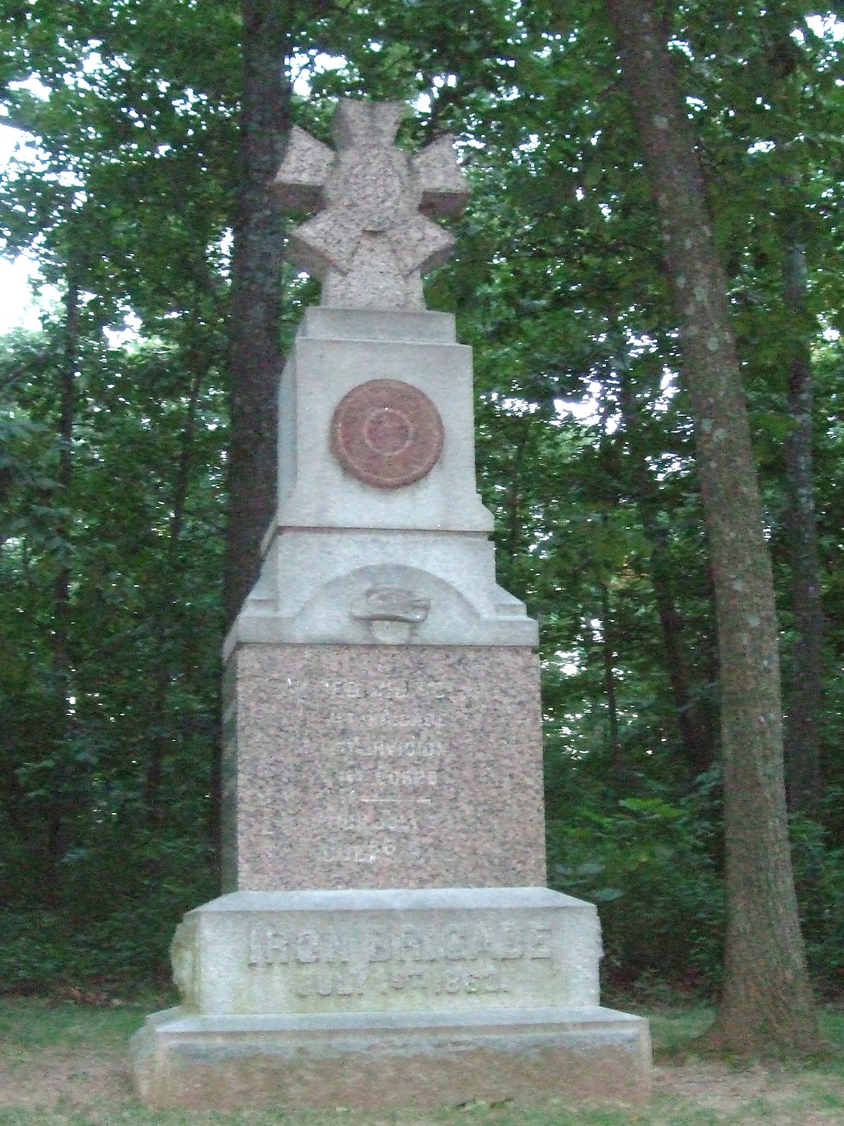
Gettysburg visitors and locals are familiar with the detailed, moving monuments to all the troops that served. These monuments are often located near or at the position of a particular groups at Gettysburg. The monuments of the battlefield tell the story, often listing the number engaged, and the numbers killed, wounded, and missing. Some will also list the other battles in which a brigade or battery participated. The most detailed will include the place and date in which the soldiers were mustered in and out. You may be surprised to discover where and when the soldiers were officially no longer serving, since some of the men were mustered out far from home at the end of the Civil War. You can watch the cars drive by and slow down to read the monuments. Even the children and teens in the party are often intrigued by the emotion and art that pair with stone to create a lasting reminder for us of the sacrifices and the bravery of those who fought. This monument to the 
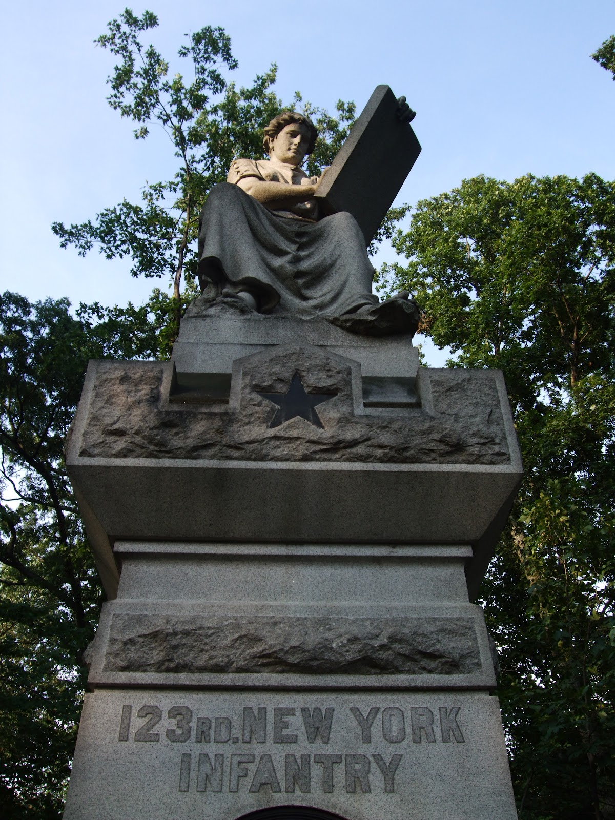
123rd New York Infantry exemplifies that blend of emotion and art. Lit by the rays of the setting sun Clio, the Muse of history is writing down the record of the 123rd's service. On the monument, the star indicates that this troop belonged to the Twelfth Corps. All the Twelfth Corps monuments feature a star in some place. on the monument.
These monuments, often majestic and intriguing, will make people stop or slow down. However, less imposing, smaller, markers can also tell the story. Battlefield visitors walk right by these because they do not usually feature designs and often have just a few cryptic letters. To really learn about the battlefield requires a visitor to slow down -- and look down. The details of the battle story are right there in the position markers. Position markers are full of information, once you know how to decipher the few letters inscribed on them. Many are hard to read and require you to get down next to them, but doing so will help you to really see how the troops were placed. Usually placed at the same time as the larger monuments, the position markers can tell the location of the flanks -- or sides. These flank markers tell how far the line extended on either side. You can identify the right flank and the left flank by reading the monument. Thus R. F. means right flank and L.F. means left flank. Occasionally, the position markers will include dates. These markers were placed in most cases when veterans of the battle were still alive to describe the location, and they are so valuable because they tell us much about the soldiers. This is a position marker for the 123rd NY Infantry.

On this position marker, you can identify that they belonged to the Twelfth Corps by the star. This marker also includes the dates July 2 & 3 1863, and stipulates that this was the left flank. You can stand at a position marker and figure out which way the soldiers were moving, or where there attackers were located. This is a very complete marker; some are more abbreviated or harder to decipher.


This marker, also on Culp's Hill, identifies the left flank of the 1st Maryland, of Steuart's Brigade of the CSA. Their monument is nearby this location on lower Culp's Hill.


Many markers are harder to decipher. Can you tell what the position marker on the right indicates?


This marker, also on Culp's Hill delineates the left flank of the 29th Pennsylvania Volunteers. There is a larger monument nearby that describes the service of the 485 men who comprised the 29th.


The placement of position markers can also tell which troops fought side by side. In this picture, one sees the right flank of  the 5th Ohio Volunteer Infantry and the left flank of the 147th Regiment Pennsylvania Volunteers. On the position marker of the Ohio men, you can also see the star of the Twelfth Corps.


The story of the 66th Ohio Volunteer Infantry is told at the top of Culp's Hill. There you will find their monument on the east side of the hill. Close by is the position marker identifying the right flank.
The rest of the story is told several hundred yards down a steep path on the heavily forested east side of the hill. Here perched atop a boulder is the left flank monument. Finding it is well worth the walk down the steep hill because standing on the boulder and looking out toward the east, and down toward where the Confederate troops were gives you a sense of place, a sense of the wooded battlefield in which these men fought. I walked down on one of those humid 90 plus degree days of mid-July and found just walking to be difficult. The Ohio position markers, however, are not placed in the same manner as others. You can discover the arduous process of ordering and placing the monuments by reading the entries here:
 http://www.gettysburgdaily.com/?p=13072


 The next time you are walking through the winding roads of the battlefield, take a look down and find the position markers. Once you can decipher them, you will discover much more about the men who fought here.


Wednesday, July 18, 2012

Pardee Field on Culp's Hill

"This they did in handsome style"

Locals are likely to walk in the area of Devil's Den, and to know more about the battle for the Round Tops. Getting to know Culp's Hill is an adventure since this area has undergone recent changes during the NPS clearing of trees. A drive along Geary Avenue proceeding away from Spangler's Spring leads one past an open meadow in which several paths have been mowed. This road slowly climbs to the lower part of Culp's Hill. The avenue winds through what was one large field in 1863. Nearly in the center of that meadow, surrounded by grass and wildflowers stands a single boulder, placed in 1905 by the Commonwealth of Pennsylvania, and inscribed in 1906 with two words: Pardee Field. This area, named for the commander of the 147th,  has been cleared of trees and restored to the meadow that was once there. It is actually located between Slocum Avenue above, and Geary Avenue below. As you drive along the battlefield, you note that most of the monuments are granite or limestone, and range in color from ivory to gray. The boulder in Pardee Field however, appears almost golden in the sunlight. It was brought to this site from elsewhere and has been described variously as sandstone or granite. On the left side of the monument is a bronze plaque which tells the tale of how this five acre meadow was the path for the Pennsylvania 147th Infantry to regain ground that had been briefly held by Steuart's Brigade, CSA.
At 5 a.m. the one hundred and forty-
seventh Penna. Volunteers (Lt. Col. Ario Pardee Jr.)
was ordered to charge and carry the stone
wall occupied by the enemy. This they did in
handsome style, their firing causing heavy
loss to the enemy who then abandoned
the entire line of the stone wall.
Report of Brig. General John W. Geary,
commanding 2d Division 12th Corps

At 5 a.m. on July 3,  troops from the Army of the Potomac, including the 147th and the Seventh and Fifth Volunteer regiments from Ohio did advance here and retake the area that had been briefly held by the First Maryland CSA of Steuart's Brigade. Accounts differ and tell a tale of the importance of skirmishers in engaging the enemy. Pardee himself wrote following the battle:
"On the morning of the 3d, we marched to a point near the line of the previous day and toward the right of the line of the brigade, having on our right the Seventh Regiment Ohio Volunteers and on our left the Fifth Regiment Ohio Volunteers. Soon after the line was formed, I was ordered by General Geary, commanding division, to move forward with my regiment to a point which commanded the right of the line of entrenchments, and from which a view could be had of the movements of the enemy. My regiment, soon after reaching its assigned position, became engaged with the skirmishers of the enemy, who were soon driven from their position. Skirmishers were sent to the front and right flank, into the woods, from which they greatly harassed the enemy. At about 8 a.m. an attempt was made by the enemy to turn the right of the line of the entrenchments. They boldly advanced to within about 100 yards without discovering my regiment. I then ordered the regiment to fire, and broke their line. They reformed again as a body and advanced. Their advance was checked by the heavy fire they received, when they broke and ran."

 On the other side of Geary Avenue lies this monument to the 147th erected by the Commonwealth of Pennsylvania in 1885, which states:  On the night of July 1st this regiment lay on the northern slope of Little Round Top holding the extreme left of the Union Army. At 6 a m July 2d moved to Culp's Hill where it was held in reserve until evening, then marched toward the left with the Brigade. Returning at about 3 a m July 3d and occupied this position. Of the 12 officers and 286 men present at Gettysburg, one officer and five men were killed and 14 men were wounded.On the day that I took this picture, the sun in the west added a second star to the monument.
The story of what happened in the meadow that has come to be known as Pardee Field is the story of the bravery and fortitude of men who were ordered to advance and take ground, and accomplished that goal. It is a story with two sides, because on the other side of that stone wall lies a marker which shows the farthest advance of the 1st Maryland CSA, and their story will be the another post. 
Getting to Pardee Field is an easy walk from Spangler's Spring along Geary Avenue. As you walk, note the monuments to the Fifth Ohio and 147th Pennsylvania, then walk up the incline to the Pardee Field monument, retracing the movements of those troops on July 3, 1863. 

As you walk through the meadow, watch for dragonflies and butterflies. This picture captured an insect on a milkweed plant. In Pardee Field, naturalists have identified the presence of the hoary frostweed, a species identified as endangered in Pennsylvania. I have not yet seen the plant, which has yellow flowers.
http://www.nps.gov/nero/science/FINAL/GETT-EISE_T%2BEplants/hoary_frostweed2.pdf
Bring a camera because the meadow and monuments will be perfect photo opportunities.
After you leave the monument, continue on a path upward to the stone wall that the men were ordered to take. Just on the other side of that wall is a small positional marker indicating the farthest point occupied by the First Maryland, CSA of Steuart's Brigade. You can continue back along Slocum Avenue to the parking lot at Spangler's Spring,

Monday, July 16, 2012

Reid's Orchard Winery

Beautiful Drive, Wonderful Wine


Reid's Orchard Winery is well worth the trip to the beautiful Buchanan Valley. The tasting room is located just off Buchanan Valley Road, surrounded by orchards. The orchard hosts free concerts, often featuring local artists throughout the summer. Go for the apple cherry wine, which is a perfect blend of summer sweetness and autumn tang. Like other local wineries, Reid's also has an "in-town" site, at Jennie Wade's birthplace, 242 Baltimore Street in Gettysburg.

Local Fruit, Local Grapes

 As you approach the tasting room, notice the grape vine laden with grapes. If you have brought the family, this is an excellent place to talk about how grapes grow. When I was there in early July, there were bunches still green. Local, local, local! Reid's grows its own fruit and grapes or purchases excess from other local growers. This means the fruit does not have to be trucked for long distances and can be used at the peak of sweetness, In Adams County, surrounded by orchards, the fruit wines seem especially appropriate. Fruit wines abound at Reid's, and range in sweetness and flavor. The strawberry wine is not cloyingly sweet like some that are sold; it is more complex and interesting. Apple cherry was my favorite choice, and has been been a family favorite. Other fruit wines include apple & blueberry
The wine that whispers summer and promises evenings under the stars is Volunteer. I would drive twice as far to get it! This wine is a fortuitous meeting of Catawba, Concord, and Cayuga grapes. Red wines include a popular Merlot, Seminary Ridge Red, Richmond Rebel, Angels of the Battlefield Cabernet Sauvignon, a Pinot Noir, and Troika. I am definitely going back for Muskets of Maine Moscato, one of the whites and a Chardonnay (there are three Chardonnay choices available). Other white wines include Pinot Grigio and Sharpshooter Cayuga.

As you can see, the labels refer to Gettysburg or Civil War subjects in most cases, and thus the wines will be excellent mementos of a visit to Gettysburg -- or for locals, a reminder of how lucky we are.

A Word about Prices for Local Wines

Local wines, like micro-brewery beer are not mass produced. Thus, the prices are in line with mid-price wines, not the cut rate prices. But paying for local products is well worth the money. Often, the wines are created from local fruits and grapes as is the case with Reid's and other local wineries. Supporting local businesses is a pleasure, especially when they offer wines that far surpass the mass produced ones at the liquor store.  And for all the Gettysburg locals, start planning weekend afternoons at Reid's.


 http://www.reidsorchardwinery.com/

 http://www.gettysburgwineandfruittrail.com/